History
The county of Wittgenstein was created in 1238 by splitting the county of Battenberg. The area consisted of 488 km2 = 188 square miles along the headwaters of Eder and Lahn. In 1605, the county was further split into the independent counties of Wittgenstein-Berleburg and Wittgenstein-Wittgenstein.
The first rulers were the counts of Wittgenstein and, when their line had died, the counts of Sayn. In 1792, the Berleburg line was promoted to “princes”; the Wittgenstein line followed in 1801.
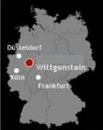
In 1806 both areas became part of Hessen-Darmstadt by order of the French emperor Napoleon. In 1816, as a result of the Congress of Vienna Hessen-Darmstadt ceded the territories to Prussia. They were united to “Kreis Wittgenstein” as part of the Prussian province Westphalia.
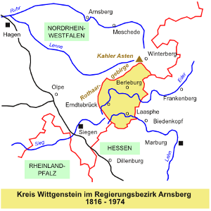
Since 1946, the Kreis Wittgenstein is part of the state of North Rhine-Westphalia. In 1975, Wittgenstein was united with the Kreis Siegen, renamed Siegen-Wittgenstein in 1984.
In 1975 the villages Langewiese, Mollseifen und Neuastenberg and the hamlet Hoheleye became part of the town of Winterberg, Hochsauerlandkreis. The remaining 54 towns and villages were united to the towns of Bad (spa) Berleburg and Bad Laasphe as well as the village of Erndtebrück.
All communities within the Kreis Wittgenstein, which existed as independent entities until December 31st, 1974, are listed on the following page.
Organizational details for government and church in Wittgenstein are available at GenWiki .